"Folks livin' in the delta fear two things: God and the Mississippi River."
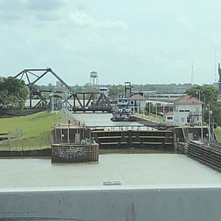
After spending several days in the delta region, it is easy to see why this statement is true. The Mississippi is the economic life-blood of this region (and the country) and is a constant buzz of activity. We saw cargo ships of all sizes plying the waters along with hundreds of powerful tug boats pushing heavily laden, flat-bottomed barges in all directions.

Having camped close to the river, I can tell you it never sleeps. And the rumble from the powerful engines on these tugs can make it seem like you're living next to railroad tracks!
Every where you look throughout New Orleans and the surrounding areas you see an exotic labyrinth of levees, locks, dams, dikes, pumps, over-spills, and canals. These are used by the Army Corp of Engineers in its battle to keep the river waters flowing in a predictable direction.
I found this interesting graphic online showing how far below the surrounding sea levels New Orleans actually is:

I wasn't aware of this but throughout its history, the Mississippi River has writhed like a "snake on hot asphalt". Twisting, changing, turning, bending. It is in a constant flux. As it was told to us, it is currently trying to shift its flow westward toward the Atchafalaya River. Because of the devastating consequences this would have on the region and perhaps the country, the Army Corp carefully and constantly regulates the relationship between these two rivers.

Below are some of the other sight seeing activities that we undertook:
Hurricane Katrina:
As you talk with locals we often heard the phrase "Pre-K" and "Post-K". This refers to things that used to exist before Katrina but are no longer around. It can be in reference to homes, or neighborhoods, or roads, or bridges, or restaurants etc.. Most of these are gone, never to return.
On August 29, 2005, Hurricane Katrina struck the Gulf Coast. When the storm made landfall, it had a Category 3 rating with winds of 100–140 miles per hour, and stretched some 400 miles across. Its devastation was deep and wide-spread. Eventually 80% of the city and large tracts of neighboring parishes became flooded, and the floodwaters lingered for weeks. I think most of us remember seeing the images of swollen rivers, flooded streets, displaced residents and of course the heart-wrenching body bags.
In order to get a better understanding of Katrina's impact on the area, we decided to drive around the Ninth Ward where the flooding was the worst. Hard to believe but THIRTEEN years later there is still lingering storm damage.


In the picture below, you see the spot of the largest of the levee breaks. This is the 17th Street Canal Floodwall mentioned in the historical marker above. You can see the wide-spread impact of this rupture.

The yellow arrow in the picture below, points to the spot where the floodwall was breached. Nothing has been rebuilt on that plot of land. Most of the houses you see in the picture above have been torn down. A few new homes have begun to spring up. The roads in the area were in horrible shape with cracks, buckles and large pot holes.

We traveled about 20 minutes south to visit the Edward Herbert Defense Complex.

Here's a bird's eye view of the complex I found online.

It was built during WW I as a naval base and was heavily damaged during Katrina. Because of the extent of the damage (so we were told), it was never reopened. Ownership was transferred to the city of New Orleans five years ago with plans of turning it into a hub for disaster and emergency response agencies.
Here are a few other pictures that I took of the complex from behind the chain link fence:
Even though its suppose to be patrolled by an army of security guards, graffiti artists (some quite talented) obviously had no problems gaining access.
New Orleans at Night:
Lorraine and I took a dinner cruise on the paddle-wheeled steamer, Creole Queen. It provided a panoramic view of the city as we dined on seafood gumbo and jambalaya.


Shotgun Houses:
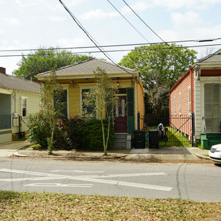
Throughout New Orleans you see these tiny houses called a "shotgun house." They are narrow rectangular residences usually no more than about 12 feet wide! It is said you could fire a shotgun through the front door, have the buck-shot pass through every room in the house then exit the back door.
The rooms are arranged one behind the other with doors at each end of the house. It was the most popular style of house in the Southern U.S. from the end of the Civil War through the 1920s. Some of them look quite charming from the outside. In one of the pictures below you see two individual houses sharing the same roof... these are called "double-barrel" shotgun houses!
Many of the older homes have been torn down but with the recent trend in urban renewal they have gained a resurgence in popularity.
Fish Markets:
Them boys down south love to fish! It seems you see someone fishing at every puddle of water you come across.


And there are also fish markets everywhere. One day someone told us about a popular fish market not too far from our camp ground. Since we love seafood, we decided to see if we could purchase some fresh salmon. We drove out to the market and found this:
Completely in tact but dead fish. I offered to buy the fish if Lorraine would gut and clean them, but for some reason she adamantly refused. We decided that if our fish didn't come wrapped in cellophane, we aren't going to eat it.
Other strange foods:
First, they love crawfish or otherwise known as crawdads. Every market place and roadside vendor was selling giant sacks of them. Next, pickled pork lips: don't know, don't care. And Game Tame. The name says it all.
And thus concludes our visit to the Big Easy. It was a fascinating, informative and rewarding visit. The area is steeped in history, color and culture. We also found the majority of people to be friendly and hospitable. On the downside, it can also be scary (it has some really sketchy sections and characters), loud, dirty and (believe it or not) touristy.
Next we head north to Natchez, MS.


